
Hurricane Lane, a dangerous Category 4 storm, headed toward Hawaii
CNN/Stylemagazine.com Newswire | 8/21/2018, 1:04 p.m.

Hurricane Lane, a dangerous Category 4 storm, headed toward Hawaii
By Brandon Miller, CNN Meteorologist
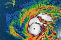
(CNN) -- Another hurricane is threatening to impact Hawaii this week, as dangerous Category 4 Hurricane Lane approaches the Central Pacific island chain just two weeks after Hurricane Hector passed the islands.
But Hurricane Lane looks poised to bring much more significant impacts to the state, as the forecast puts the storm very close to the islands, with a direct landfall is possible later this week.
Hurricane Watches have been issued for Hawaii and Maui counties, in the eastern part of the islands.
A Hurricane Watch means that hurricane conditions are possible within the watch area, according to the National Weather Service's (NWS) Central Pacific Hurricane Center in Honolulu.
Lane has maximum winds of 150 mph (240 km/h) and is about 450 miles (725 km) southeast of Hawaii's big island.
The storm is currently moving westward at 12 mph (19 km/h) and should continue to move west through tonight. But forecast models are indicating that Lane will turn in a more northerly direction by Wednesday, which will bring the center of Lane very close to Hawaii and Maui counties on Thursday, the Hurricane Center said.
Hurricane Lane poses a "potential threat to life and property," according to the NWS, and "efforts to protect property should now be underway."
More watches and even warnings could be necessary for additional islands as the storm moves closer in the next 24 to 48 hours.
Expected impacts in Hawaii
Tropical-storm-force winds could arrive on Wednesday in the Big Island, and in the smaller islands by Thursday or Friday.
In addition to strong winds, the primary threats will be rough surf, coastal erosion, and heavy rainfall, even if the center of the storm does not move directly over the islands.
Large waves are already being experienced along the eastern edge of Hawaii, with a "sizable swell already propagating out from this storm, which is currently impacting the eastern exposures throughout the Hawaiian Islands, showing strongest along the Hilo Side of the Big Island," according to Jonathan Warren, lead forecaster for Surfline.com.
While there is still considerable uncertainty in the forecast for Lane, it appears the storm will be passing close enough to the islands on Thursday and Friday to bring significant impacts to the southern portions of the islands, especially along the coastline.
"One thing is for sure, the coast will continue to feel the impacts of swell, gradually increasing with the approaching storm to a peak around mid-week with strong surf (large waves for some of the well-exposed areas)," Warren said.
The National Oceanic and Atmospheric administration has been sending multiple aircraft into and around the storm in order to help observe the hurricane and improve the forecast, providing a better idea of the threat Lane presents to Hawaii.
Unfortunately NOAA's "hurricane hunter" aircraft that flies through the center of the storm had to be grounded Tuesday morning, as it needed to be examined after "encountering strong turbulence last night" when flying through Lane, according to NOAA.
Isn't there a volcano erupting there?
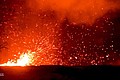
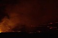
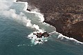
As you may have heard, Hawaii has been experiencing a volcanic eruption for much of the summer. Mount Kilauea began producing lava flows in early May and portions of the southeastern coastline of the Big Island have been transformed by the lava flows which covered over 13 square miles (35 square kilometers).
Fortunately the eruptive activity of Kilauea has "paused," with no new lava flows since August 9, according to the Hawaiian Volcano Observatory.
Since there is not much lava reaching the ocean anymore, the hurricane shouldn't have too much of an impact on the volcano region, according to Denison University Geophysicist Erik Klemetti.
But Klemetti does point out that there could be a threat of heavy rain "remobilizing some of the loose debris and ash" left in the recent lava flows.
Hurricanes in Hawaii are rare
Landfalling hurricanes are very rare in Hawaii, as the Central Pacific does not normally see as many storms as the Atlantic or Eastern Pacific, and the Hawaiian Islands present a very small target in the vast Pacific Ocean.
Only four named storms have made landfall in Hawaii since 1959 (two hurricanes and two tropical storms). Even close calls are somewhat rare, with Hawaii getting a named storm within 60 miles of its coastline about once every four years on average.
Also of interest
-
 Hurricane Lane is heading for Hawaii as a dangerous Category 4 storm -Update
-
 Lava from the Hawaii volcano has created a tiny new island off its coast
-
 Hawaiians look to volcano goddess Pele for protection as lava destroys dozens of homes
-
 It's been over two months since Hawaii's Kilauea volcano started erupting, and the lava's still flowing