Gordon could be hurricane when it hits Gulf Coast Tuesday night
CNN/Stylemagazine.com Newswire | 9/4/2018, 5:02 p.m.

South Florida was lashed by heavy rain and strong winds from Tropical Storm Gorgon Monday.
By Jason Hanna, Ed Lavandera, and Nick Valencia, CNN
(CNN) -- Tropical Storm Gordon, which may ramp up to become a Category 1 hurricane before it makes landfall late Tuesday, brought tropical-storm force winds to the Alabama and western Florida Panhandle coasts.
The National Hurricane Center said Gordon should weaken rapidly after it moves inland from the central Gulf Coast, but that doesn't diminish concerns about flooding. It could bring potentially life-threatening storm surge across parts of coastal Louisiana, Mississippi and Alabama.
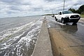
Seawater could spill onshore as high as 3 to 5 feet, spelling significant trouble for roads and towns along the coast.
"If you are less than 3 to 5 feet above sea level (in the warning area), you need to get away from that water, especially up those rivers, because that's where that water will be going," CNN meteorologist Chad Myers said.
In Bay St. Louis, Mississippi, workers cleared tables and chairs from the outdoor seating area of a bar. "This is a serious squall," said Raleigh Murphy, owner of Dan B's Restaurant and Bar. "It's part of life on the Gulf Coast, just something we have to deal with."
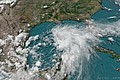
After marching up from the Florida Keys and lashing South Florida on Monday with rain, Gordon was centered Tuesday evening over the Gulf of Mexico, about 75 miles southeast of Biloxi, Mississippi, with maximum sustained winds of 70 mph.
Gordon is forecast to strengthen into a hurricane, with sustained winds of at least 74 mph, before it reaches the north central Gulf Coast, the National Hurricane Center said.
Tropical storm conditions -- winds of at least 39 mph -- could hit the Gulf Coast earlier.
Schools in parts of coastal Louisiana, Alabama, Florida and Mississippi were closed Tuesday, and others announced they would open for only part of their normal day.
Gordon could drop heavy rain -- generally 4 to 8 inches, but as many as 12 -- from Florida's western panhandle to southern Arkansas through Thursday, the National Hurricane Center said.
Floodgates close near New Orleans
Across the region, governments and residents are making preparations.
In Mobile, Alabama, people were topping off their vehicles' tanks with gas Tuesday morning.
"I just don't want to be caught somewhere where I have to leave and I can't because I don't have any gas," Cynthia James told CNN affiliate WALA.
On Dauphin Island, Alabama, residents and visitors didn't seem overly concerned. Many businesses and homeowners did not board up their windows. They were likening conditions to 2017's Hurricane Nate, which was mostly a rainmaker by the time it got there. Still, the Mobile region likely will see flooding in low-lying areas and winds up to 60 mph.
In Bay St. Louis, Murphy's bar opened last year for the first time since Hurricane Katrina; members of his family have owned it since 1982. The businessman said he was not overly concerned by Gordon's arrival.
He and his cousin, Lance, were relieved that the center of the storm was jogging more to the east. Lance Murphy, who referred to Gordon as a "party storm," said, "We just live through it and hope we can open again tomorrow."
Still, they were paying close attention to weather reports.
In coastal Mississippi's Jackson County, people filled bags with sand at government distribution points Monday, intending to line their homes with them to avert flooding.
Among them was Jose Rivera, who moved from Puerto Rico to Mississippi after Hurricane Maria devastated the island last year, CNN affiliate WLOX reported.
Rivera said he is worried about Gordon.
"He said he doesn't want the same thing that happened in Puerto Rico over here," Rivera's grandson, translating from Spanish, told the station.
Mississippi Gov. Phil Bryant, Louisiana Gov. John Bel Edwards and Alabama Gov. Kay Ivey declared emergencies. Edwards also activated 350 National Guard members.
In New Orleans, Mayor LaToya Cantrell issued a voluntary evacuation notice for areas outside the levee system.
The city expects to feel the storm's impact beginning late Tuesday and continuing through Wednesday, she said. City Hall and government offices closed Tuesday for nonessential employees.
In anticipation of heavy rains, the Flood Protection Authority-East, or FPA, closed 38 floodgates, 13 valve gates and a concrete barge gate on the Lake Borgne Surge Barrier near New Orleans, according to a news release. Another seven floodgates and the Caernarvon Sector Gate were to be closed Tuesday.
The gates are in Orleans and St. Bernard parishes, primarily along the Industrial Canal and susceptible to high-tide conditions if not closed, the city said. Levee overtopping and breaches at these locations in 2005 led to devastating flooding from Hurricane Katrina in New Orleans' Lower 9th Ward, the city's eastern swath and in St. Bernard Parish.
As of Monday night, the FPA did not expect that three pump stations and closure structures at Lake Pontchartrain would be activated but was prepared to do so if the forecast changed and water levels reach key thresholds, according to the press release.
Boats ordered out of the water in Biloxi and Gulfport
In Mississippi, vessels in the harbors of Biloxi and Gulfport were ordered to evacuate by 2 p.m. Tuesday due to the risk from storm surge there.
"We're asking people to do the same things that we're doing: prepare," Biloxi Mayor Andrew "FoFo" Gilich said in a statement. "There's no reason to be alarmed. We're being told to expect rain and wind, and we're preparing accordingly. We expect our citizens to be doing the same."
Airlines including Delta, Southwest and Frontier warned that delays and flight cancellations are possible at airports near the Gulf Coast because of the storm, and that they may waive fees for itinerary changes.
Warnings in effect
A hurricane warning was in effect Tuesday morning for all of coastal Mississippi and Alabama, with a tropical storm warning reaching to Grand Isle, Louisiana, and Florida's Okaloosa-Walton county line.
A storm surge warning was in effect for the coast between Shell Beach, Louisiana, and Dauphin Island, Alabama, with predicted heights of up to 3 to 5 feet if the peak surge coincides with high tide. A storm surge watch spread west to the mouth of the Mississippi River in Louisiana, and east to Navarre, Florida.
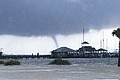
Tornadoes also are possible through Tuesday night near the Mississippi, Alabama and Florida coasts, the NHC said.