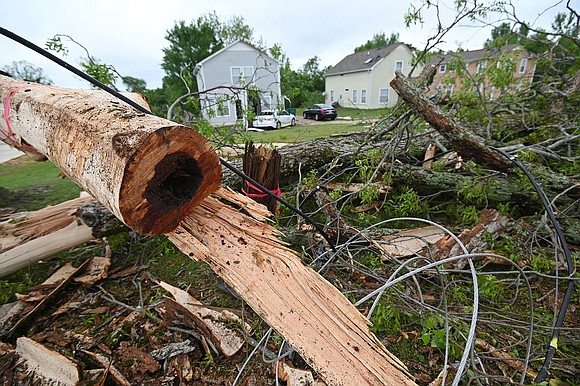
After being pummeled, Southeast US faces the threat of more storms and tornadoes
CNN/Stylemagazine.com Newswire | 5/4/2021, 12:04 p.m.

Originally Published: 04 MAY 21 03:18 ET
Updated: 04 MAY 21 11:30 ET
By Madeline Holcombe, Michael Guy and Eric Levenson, CNN
(CNN) -- About 90 million people from the US Gulf Coast to the Northeast could see severe weather on Tuesday as part of a multi-day storm outbreak.
On Sunday, tornadoes struck at least three Mississippi cities, and on Monday tornado and thunderstorm watches stretched from Mississippi to south-central North Carolina, including the metro Atlanta area where a tornado touched down and caused widespread damage. Two people in Georgia were killed by falling trees.
Tuesday's threat is much the same, as a level 3 of 5 "enhanced" risk covers a range from Louisiana to Georgia. In addition, flash flooding is also likely across the Southeast, and over 12 million people are under flash flood watches, including Atlanta.
A tornado watch was issued for 3.5 million people in portions of Mississippi and Alabama and will last until 4 p.m. CDT. The watch includes the cities of Jackson, Mississippi, and Tuscaloosa and Birmingham, Alabama.
A few tornadoes and widespread damaging winds are likely with isolated gusts to 75 mph possible, the Storm Prediction Center says. Isolated very large hail events to 2 inches in diameter are also possible with this system.
As the day progresses, the heat and humidity that accompanies the month of May in the Deep South will help to reinvigorate the atmosphere. Areas along the Gulf Coast, from East Texas to the Florida Panhandle, could see strong to severe storms pop up until the arrival of the severe gusts that come with the advancing front.
Areas from Central Louisiana, Alabama, Georgia, and Mississippi are more likely to see impacts from hail and damaging straight-line winds rather than tornadoes. But tornadoes are still possible.
In all, just over 90 million people could experience severe weather Tuesday. Close to 28 million in the Southeast could face the wrath of rain, lightning, hail, wind and possible tornadoes.
Georgia weather turns deadly
The region is still reeling from weather that killed two people in Georgia.
A Houston County resident died as a result of the weather that struck Monday, the Houston County Emergency Management Agency said in a news release. The 55-year-old woman was killed by a falling tree.
"When Fire Department crews arrived, they found a large pine tree had fallen into the living room area of the home causing substantial damage to the roof and outer walls. Tragically crews also discovered that Mrs. Carla Harris, 55, was struck by the falling tree and sustained fatal injuries," according to the news release from the Houston County Emergency Management Agency.
More than 100 miles away, a man in Douglassville, Georgia, was also killed after a tree fell on his car as a tornado touched down Monday.
The Douglas County Fire Department responded to reports of a tree on a car with a person inside around 10:36 a.m., according to a news release from county officials.
"When they arrived on the scene, they discovered the driver trapped inside the vehicle with power lines and a tree on the vehicle," Douglas County communications director Rick Martin said in the release. "Firefighters had to extricate the driver who we are only identifying as a male at this time until next of kin are notified."
Days of rain could mean flash flooding
Many states across the Southeast have seen double their normal rainfall over the last month, so even 1 to 2 inches of additional rain could lead to flash flooding.
Flash flooding will be possible across the South thanks to the combination of heavy rainfall and all the rain that has fallen in recent days and weeks. A widespread 1-3 inches of rain is forecast across this region into Tuesday night.
"Large hail, damaging wind gusts and a few tornadoes will be likely along with rainfall rates in excess of an inch per hour," said the National Weather Service office in Jackson, Mississippi.
Rounds of thunderstorms and rain showers will traverse across the Ohio and Tennessee River Valleys throughout the day Tuesday. Farther south, scattered storms will likely develop midday from eastern Texas through Georgia.
This line of storms should weaken by Wednesday morning as it approaches the East Coast, but isolated severe weather will remain possible.


