Strong tornadoes and large hail forecast today in Mississippi Valley after 23 hurt in Texas tornadoes
CNN/Stylemagazine.com Newswire | 4/13/2022, 11:14 a.m.

Originally Published: 13 APR 22 00:24 ET
Updated: 13 APR 22 11:15 ET
By Aya Elamroussi and Caitlin Kaiser, CNN
(CNN) -- A storm system sweeping the country Wednesday will dominate the central US, bringing long-track tornadoes, blizzard conditions and fuel for explosive wildfires.
The threat of tornadoes moves eastward, putting nearly 100 million people from the Great Lakes to the central Gulf Coast under some threat of severe storms. Tornadoes from this system left 23 injured Tuesday in Texas.
As the system pushes across the country, it brings along a trio of threats: damaging winds, strong tornadoes, and large hail.
The most significant threats are expected across Memphis; Evansville, Indiana; Little Rock, Arkansas; and Owensboro, Kentucky -- where more than 5 million people are under a moderate risk -- Level 4 of 5 -- for severe weather.
These cities are particularly vulnerable to wind gusts of hurricane force (74 mph and greater), tornadoes (some EF-3 and greater), as well as large hail.
Overall, severe thunderstorms could impact a large portion of the lower and mid-Mississippi Valley into the Midwest, as well as the lower Ohio Valley, the Storm Prediction Center said.
Elsewhere, parts of Montana, North Dakota and northern Minnesota could see heavy snow Wednesday into Thursday.
"Blizzard conditions are likely with blowing or drifting snow and dangerous low visibility for this area through Thursday," according to the Weather Prediction Center.
"Travel will remain difficult to impossible, and widespread power outages and tree damage are expected," it warns, adding there may be significant impacts to livestock such as cattle, which are in calving season.
The snow is expected to end by Friday morning, followed by extremely cold temperatures.
"Overnight lows will drop into the teens in western North Dakota, and with the strong winds, wind chills will be in the single digits above to below zero, quite chilly for mid April," the Bismarck weather service office said.
On Friday, high temperatures could make it into the 20s, which is about 30 degrees below normal. The region could break low maximum temperature records.
Critical fire conditions also remain pressing Wednesday throughout much of New Mexico, Texas and parts of the central Plains, following destructive wildfires on Tuesday.
Extremely dry air behind the cold front, in addition to strong westerly winds and very dry fuels, will result in active fire weather conditions Wednesday, according to the Storm Prediction Center.
Storm leaves destruction in its wake
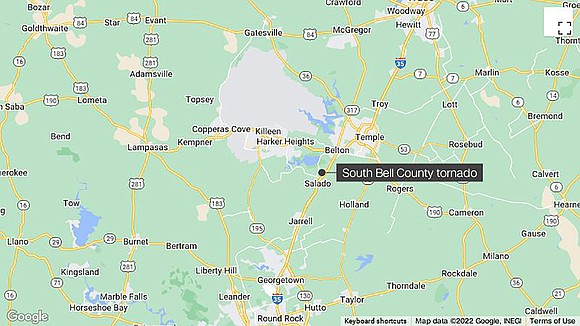
At least 23 people were hurt Tuesday after tornadoes touched down in Bell County in central Texas, according to officials. Twelve of those were hospitalized, Bell County Judge David Blackburn said, adding that he believes everyone is accounted for.
Two confirmed tornadoes touched down in Bell County, the Storm Prediction Center said.
Callers to 911 Tuesday reported a twister around 5:40 p.m. CT (6:40 p.m. ET), Blackburn said. A tornado crossed the county line from neighboring Williamson County, traveling 7 miles on the ground, he added.
The damages ranged from downed power lines and trees to buildings being flattened, reduced to rubble in many areas, Blackburn said.
"I think it popped up fairly quickly," Blackburn said. "The extent of damage is significant. At least at this time not to have any report of fatalities is in and of itself amazing."
Tuesday brought a double-threat storm system that delivered at least eight tornadoes mainly in Texas and Iowa, as well as heavy snow to other states, including the Dakotas, Montana and Minnesota.
Parts of the Dakotas and Montana were under blizzard warnings, and forecasters warned of treacherous whiteout conditions on the roads.
Heavy snow shut down more than 500 miles of interstate 94 between Montana and North Dakota.
A mountainous area near Pony, Montana, recorded 47 inches of snow in a 24-hour period, according to the National Weather Service. Many other parts of the state were pounded by more than a foot of snow.
In North Dakota, more than a foot of snow was reported in several locations, including Grand Forks and Rockford, according to weather service data.
"We do get blizzards in April, but one of this intensity is quite rare," Jeff Schild, meteorologist for the weather service office in Bismarck, told CNN early Tuesday. "The last one of note for this level of intensity was April 4-7 in 1997."
In contrast to the snowy conditions across the northern Plains, devastating wildfires were seen in New Mexico as a result of extremely critical fire conditions further south.
A 4,000-acre wildfire in New Mexico destroyed or damaged 150 structures Tuesday near the town of Ruidoso, while another major wildfire has scorched approximately 900 acres near Albuquerque.


