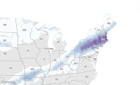
Quick/intense nor’easter could deliver New York City’s biggest snow in more than 2 years
Mary Gilbert, CNN Meteorologist | 2/12/2024, 8:53 a.m.
A quick but intense nor’easter could bring the biggest snowfall in more than two years to parts of the Northeast Tuesday, including New York City.
But the forecast is tricky and subject to last-minute changes. With the heaviest snow developing over a narrow area, small shifts in the track will make a big difference in how much snow falls.
The nor’easter – an East Coast storm driven by winds from the northeast – will develop Monday night from the same sprawling system that soaked the Gulf Coast and Southeast over the weekend and is threatening more flooding and severe thunderstorms in the region Monday.
Widespread heavy snowfall is forecast to set in overnight Monday into Tuesday from Pennsylvania through southern New York and northern New Jersey, where winter storm alerts are in place.
More than 2 inches of snow per hour could fall across the impacted region Monday night and Tuesday morning – coupled with wind gusts as strong as 40 mph, the Weather Prediction Center said.
“Travel could be very difficult to impossible. Patchy blowing snow could significantly reduce visibility. The hazardous conditions will impact the Tuesday morning and evening commute,” the National Weather Service said in an alert.
The heaviest stretch of snow is expected to be quite narrow. Snowfall totals could vary drastically for cities separated by just 20 to 30 miles, and snow may struggle to accumulate at first before finally piling up quickly because of springlike temperatures leading up to the storm.
For New York City, the heaviest snow is forecast to occur just north of the densely populated metro. But a slight shift south in the storm’s track would mean more snow in the city, while a north shift would mean less.
Around 5 to 8 inches are forecast for the New York City area. If the city picks up at least 6 inches of snow, it’ll be the biggest storm for the city since January 2022.
On Tuesday, the threat expands to southern New England, where cities including Boston and Hartford, Connecticut, could see up to a foot of snow.
Boston hasn’t recorded a double-digit snowfall in a single day in over two years.
The snowy weather will be quite a change of pace for the region, as many cities in the Northeast are dealing with their warmest winter on record. But February is historically the snowiest month of the year for many of the region’s major cities because of nor’easters like this one.
Local officials have already begun gearing up for the incoming snow. New York Gov. Kathy Hochul on Saturday urged residents to watch the weather forecast and prepare for potentially hazardous travel conditions and power outages.
“I have directed State agencies to mobilize in preparation for this storm and urge everyone to watch for weather and travel updates as it develops,” Hochul said.
Moderate coastal flooding could also occur during high tide Tuesday along parts of the New Jersey, New York and New England coasts.
Severe thunderstorms and flooding in Southeast
The storm is unloading heavy rain Monday in the Southeast, raising the flood threat there. Storms could also produce hail and potentially a few tornadoes in the region, prompting a tornado watch.
Around 33 million people from Mississippi to the Florida Panhandle and into the Carolinas are at risk of severe thunderstorms and excessive rainfall, according to the National Weather Service.
Major cities at risk include Atlanta, Birmingham and Montgomery, Alabama; Tallahassee, Florida; and Charlotte, North Carolina.
Tornado watches were in place in parts of far southeast Louisiana, southern Mississippi, Alabama and the Florida Panhandle through Monday morning. The weather service in Jackson, Mississippi warned of golf ball-sized hail and damaging winds within severe storms.
Flood watches are also in effect Monday from central and eastern Alabama and southeastern Tennessee through Georgia and South Carolina due to the risk of excessive rainfall.


