
Nor'easter will likely bring most significant spring snow in years
CNN/Stylemagazine.com Newswire | 3/20/2018, 1:30 p.m.

By Judson Jones, CNN
(CNN) -- It's the first day of spring, but the Northeast can't seem to shake off winter.
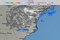
The fourth nor'easter in three weeks will hit the region Wednesday, bringing heavy snow and winds. If the current forecast pans out, this Nor'easter will dump more snow on Washington, Philadelphia and New York City than the three earlier storms combined.
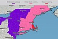
More than 70 million people are under a winter storm watch, warning or advisory from the southern Appalachians to Boston.
A complex storm system that struck parts of the Southeast with severe storms Monday will move off the North Carolina coast Tuesday evening. By Wednesday morning, it will form near the Outer Banks and track to the Northeast.
Heavy snow possible for early spring
Northern West Virginia and southern Pennsylvania have already begun to see some snow Tuesday.
Track the storm with high resolution auto-updating graphics
Washington will first see a wintry mix that will turn to snow Wednesday. The nation's capital will likely receive 2 to 6 inches of winter precipitation, with some models hinting at much higher totals for the District. It all depends on how fast the temperature drops. Just west and north of the city is more likely to see close to a foot of snow.
"It's been 75 years since Washington has had 5 inches of snowfall or greater this late in the season," CNN senior meteorologist Brandon Miller says.
The wintry mix will arrive later Tuesday in Philadelphia and the surrounding area. It will turn to snow overnight, with 1 to 3 inches per hour by midday Wednesday. The city may get its biggest snowfall after the first day of spring in more than 100 years, with 12 inches expected.
New York could break 1958 record
In New York City, snow will begin to fall by daybreak Wednesday. Six inches to a foot is forecast before the storm departs early Thursday.
"If (New York) gets 12 inches of snow -- the National Weather Service currently has a high-end forecast of 14 inches -- it would be (its) largest snowfall ever recorded after the first day of spring," Miller says.
The current record is 11.8 inches, set on March 21, 1958.
With these late winter storms, it is difficult to predict snowfall amounts because of the mixing of warmer air. In some of the earlier nor'easters, the air near the ground has stayed warm enough that places like New York have seen lots of snow fall from the sky but had little accumulation. An urban heat island effect is plausible once again with this spring storm.
Boston stayed on the warmer side in the first two nor'easters but then got walloped with snow during the third storm this month. The city is likely to see another 8 to 12 inches of snow, adding to the 20-plus inches it has already received in March.
If Boston does get up to 12 inches, the city would have its second snowiest March on record.
These late winter storms are likely to become more frequent with climate change. A study last week in the scientific journal Nature Communications ties extreme winter weather, specifically major snowstorms in the Northeast, to warming Arctic temperatures.
Blizzard conditions likely
With a forecast of heavy snow and winds more than 45 mph, blizzard conditions are possible. New York City could see sustained winds of 20 to 30 mph Wednesday, and coastal areas such as Cape Cod in Massachusetts are predicted to receive gusts up to 60 mph from midmorning Wednesday to Thursday.
What is makes a snow storm a blizzard
After a battering from a month of coastal storms, storm surges will continue eroding coastlines. The extent of coastal flooding experienced in the first two nor'easters is unlikely, but the new flooding will have an impact on already weakened and vulnerable areas. Some coastal flooding will likely happen during high tide cycles Tuesday through Thursday from the mid-Atlantic to New England.
More severe storms in the South
Like Monday's severe storms, the potential for damaging winds and tornadic activity will be possible Tuesday for South Georgia and Florida.
The storms will likely regenerate Tuesday afternoon and evening from Miami to the Outer Banks of North Carolina.
There is an enhanced risk for severe thunderstorms, with wind, large hail and a few tornadoes possible.
Also of interest
-
 Is it really spring? 4th nor'easter in 3 weeks closes schools, delays flights
-
 Keep Out the Snow Shovel. Another Nor'easter, 'Bomb Cyclone' Expected
-
 Blizzard slams New England in third major storm of past 2 weeks
-
 Northeast Snowstorm Shifts From New York City; 15M Under Blizzard Warning
-
 Iowa Braces for 'Life-Threatening' Blizzard, South and East Coast Face Record Lows and Tornado Risks