Hurricane Willa expected to wallop Mexico's Pacific coast with explosive storm surge, rain and dangerous waves
CNN/Stylemagazine.com Newswire | 10/23/2018, 11:56 a.m.

By Matt Rehbein and Brandon Miller, CNN
(CNN) -- Mexico is bracing for what's expected to be one of the strongest storms to hit its Pacific coast.
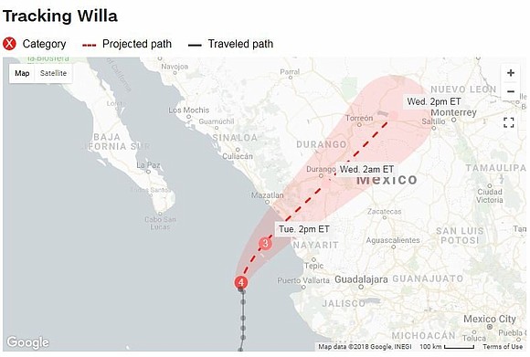
Hurricane Willa is aiming for the west-central coast Tuesday afternoon or evening. On Tuesday morning, the storm boasted maximum sustained winds of 125 mph and threatened to bring life-threatening storm surge and torrents of rain ashore, according to the National Hurricane Center.
Willa weakened slightly to a Category 3 hurricane Tuesday and was expected to do so gradually until landfall.
The storm swirled Tuesday morning about 35 miles west-southwest of Islas Maria, an archipelago of four Mexican islands. The largest of the islands, Isla Maria Madre, is home to about 1,200 residents and a federal prison. It will likely be hit first and hardest.
After landfall, Willa is expected to weaken dramatically, becoming a rainmaker by the time it crosses the US-Mexico border Wednesday.
Forming Saturday, Willa went from a tropical storm to a Category 5 hurricane in two days in what the hurricane center called "explosive" strengthening. In one 24-hour period, its winds spiked by 80 mph.
The growth was only slightly hampered by Monday's slowdown.
"While gradual weakening is forecast (Tuesday), Willa is expected to be a dangerous major hurricane when it reaches the coast of Mexico," the hurricane center said.
Storm surge accompanied by "large and destructive waves" are forecast along portions of Mexico's central and southwestern coast. Rainfall ranging from 6 to 12 inches could spawn life-threatening landslides and flash flooding in portions of the Mexican states of Jalisco, Nayarit and Sinaloa.
Willa has been a danger for forecasters as well. An aircraft with the Air Force Reserve's Hurricane Hunters was forced to turn around Monday over concerns for its onboard equipment after a lightning bolt from one of Willa's outer rain bands blasted it, according to the National Hurricane Center.
In a tweet Monday, Mexican President Enrique Peña Nieto said he has asked the National System of Civil Protection to take all steps necessary to protect those in the hurricane's path as well as those affected by Tropical Storm Vicente, a weaker system tracking south of Willa that's also primed to make landfall Tuesday. Vicente likely will be a tropical depression by the time it comes ashore, the hurricane center said.
Airlines have started moving out of Willa's path. Southwest Airlines has canceled all flights at the international airport in Puerto Vallarta, a resort city in Jalisco state. American Airlines has canceled its flights in Mazatlán, about 275 miles to the north.
Willa's landfall will come three years to the day after the strongest hurricane to hit the Pacific coast, Patricia, a Category 5 storm, made landfall in Jalisco.
The back-to-back systems of Willa and Vicente have helped make the 2018 hurricane season in the northeast Pacific one for the record books.
The season is now the most active hurricane season on record using a measurement called accumulated cyclone energy, which combines the number of storms and their intensity through their lifetimes to give an overall measurement of tropical activity in a given region.
There have been 10 major hurricanes this year, including Willa, tying 1992 as the most major hurricanes in the northeast Pacific in one year.
Increasing numbers of major hurricanes, along with a greater propensity of storms to undergo "rapid intensification" are expected consequences of warmer ocean waters resulting from climate change. The ocean waters off Mexico's western coast are running 1 to 2 degrees Fahrenheit above average for late October.


