A travel nightmare is setting up from coast to coast as holiday travelers return home
CNN/Stylemagazine.com Newswire | 12/27/2021, 12:48 p.m.

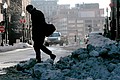
Ice and snow, rain and freezing temperatures will impact millions on their journey home from their holidays.
Mandatory Credit: CNN Weather
Originally Published: 27 DEC 21 13:25 ET
By Jennifer Gray, CNN meteorologist
(CNN) -- As the holiday hangover starts to wear off and the daunting trip home is facing you head on, Mother Nature isn't offering any favors.
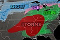
Looks like the weather from coast to coast is putting on one last show for the final week of 2021. Ice and snow, rain and freezing temperatures will impact millions on their journey home from their holidays.
This will make for extremely dangerous conditions on the roads and the possibility of even more airline delays on top of those already caused by the surging coronavirus.
Feet of mountain snow
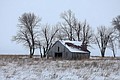
The Pacific Northwest has already been blanketed with a post-Christmas layer of snow and bitter cold.
More snow is on the way for the region, with 1 to 3 inches possible at lower elevations this week -- and more unseasonably cold temperatures to come.
The Sierra could again be measuring snow in feet, adding to an already impressive snowpack.
"The Sierra Nevada are expected to receive another 1 to 2 feet of snow with totals up to 3 feet possible in the highest elevations," said the Weather Prediction Center.
While the snow is welcomed in this drought-stricken region, it could make for dangerous conditions for the passes.
In Nevada, injuries were reported in a 20-car pileup that happened Sunday after snow and wind created whiteout conditions.
Even the Rockies will pick up 1 to 2 feet of snow. With the fresh snow and high winds, avalanches will be a huge concern.
Avalanche warnings have been issues across portions of northern Colorado and Utah for backcountry skiers.
"Heavy dense snowfall and strong winds will likely create dangerous avalanche conditions. Both human-triggered and natural avalanches are likely. Stay off of and out from under slopes steeper than 30 degrees," said the Utah Avalanche Center.
In Colorado, their first avalanche death of the season happened on Christmas Eve after a backcountry skier was "fully buried" by an avalanche.
Snow, ice and rain
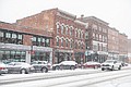
In the East, snow is falling from the Dakotas to the Northeast and will continue through the day.
While most of the snow will be relatively light, it could pile up in some locations, especially in Minnesota.
"Totals over 6 inches are possible in the Minnesota Arrowhead," said the WPC.
Blizzard conditions are even possible for portions of North Dakota and Minnesota, making for extremely dangerous travel and whiteout conditions.
Winds gusting as high as 45 mph at times, causing snow drifts to pile as deep as 5 feet, according to the National Weather Service office in Bismarck, North Dakota.
A wintry mix across portions of upstate New York and Pennsylvania will also make for dangerous conditions on the roads.
Accumulation should remain less than a quarter of an inch, but slick spots will easily develop on roads and bridges.
After this system, another one will impact many of the same regions on Tuesday into Wednesday.
The next system will bring another round of snow for parts of the Ohio Valley and Great Lakes.
Areas further south will receive all rain. Most of the rain totals will stay under 2 inches. Some isolated locations could see more.
Contrasting temperatures from coast to coast
The coldest temperatures this week will be across the northern Plains where many areas will struggle to get above zero.
Along with the cold will come strong winds, creating bitter wind chills.
"Blustery conditions will lead to dangerously cold wind chills ranging as low cold as -30 to -50 degrees, leading to the issuance of Wind Chill Warnings and Advisories," said the WPC.
Bismark is one of those places. The NWS office there issued this stark warning: "The cold wind chills as low as 25 below zero could cause frostbite on exposed skin in as little as 30 minutes."
Just outside of Seattle, temperatures Sunday morning were reported at just 10 degrees with a 50 mph wind, making for a dangerous wind chill of nearly 20 degrees below zero.
This is extremely unusual for this area, which normally has a high temperature in the mid 40s this time of year.
Temperatures for Seattle will likely stay below freezing until Thursday.
While the West will be dealing with the extreme cold, those in the Southeast will continue to need their shorts and flip flops.
On Christmas day record heat stretched from Texas to Virginia. Houston set a record at 84 degrees along with little Rock at 78, Nashville at 76 and Cincinnati at 69.
High temperatures for the South will remain 20 to 35 degrees above normal this week.
More than 250 record warm highs and lows could be broken Tuesday and Wednesday with high temperatures in the 70s and 80s from Texas to the Carolinas.
Early New Year's Eve forecast
While New Year's Eve is still pretty far out for a accurate forecast, models are hinting at yet another system impacting the Pacific Northwest.
By New Year's Eve night it should be winding down, but more rain and snow could impact the region.
Rain could soak the Southwest as we ring in the New Year. From Southern California to Arizona, quite a bit of rain could fall on the holiday weekend.
More snow is forecast for the Rockies as well.
The eastern half of the country looks relatively quiet for New Year's Eve, aside from a few showers in the Southeast and some snow for northern New England.
The temperature trend will be much as it is now, with warmer than normal temperatures across much of the East, and cooler temperatures in the West.
New York City could even be on the mild side as temperatures could hit 50 degrees on New Year's Eve, with mainly dry conditions.
By New Year's Day, all could change as we watch the potential for severe weather to set up across the Plains and the mid-South.
It's still a little early to tell, but we could see the potential for strong to severe storms to impact the region on the first night of the new year.
Temperatures will also begin to fall again for the areas that have been enjoying warmer than normal weather.
The strong front that will bring rain and storms will also bring cooler weather for the start of 2022.
Also of interest
-
 Snow, sleet and freezing rain to cross the US in series of storms
-
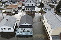 Vicious storm triggers historic coastal flooding - Arctic chill chaser battered US
-
 Northwest faces freezing rain/heavy snow - Arctic blast loosens grip on eastern US
-
 Frigid Weather Will Usher in the New Year in the Midwest and Eastern US
-
 Iowa Braces for 'Life-Threatening' Blizzard, South and East Coast Face Record Lows and Tornado Risks