The remnants of Hurricane Agatha could become Alex this week
CNN/Stylemagazine.com Newswire | 5/31/2022, 2:14 p.m.

Originally Published: 31 MAY 22 12:51 ET
Updated: 31 MAY 22 14:59 ET
By Judson Jones, CNN Meteorologist
(CNN) -- After making landfall Monday afternoon as a Category 2 hurricane just west of Puerto Angel, Mexico, Agatha rapidly weakened and is now just a remnant low-pressure system, according to the National Hurricane Center (NHC).
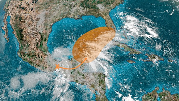
However, some of the remnants of this storm could drift east, help spark a storm off the eastern coast of Mexico and threaten Florida by this weekend.
"Global model guidance continues to suggest that Agatha's remnants will become absorbed by a larger low-level cyclonic gyre over southeastern Mexico during the next couple of days, with that new system having development potential over the northwestern Caribbean Sea and southeastern Gulf of Mexico by late this week," the National Hurricane Center said Tuesday morning.
A low-level, cyclonic gyre is a large-scale pattern of spinning winds in the lower atmosphere.
Sign up to get weekly updates from CNN meteorologist throughout hurricane season
The NHC believes there is a 30% chance this gyre and the remnants of Agatha will spawn a tropical depression over the next two days and an even higher chance, 70%, of it developing over the next 5 days.
"Regardless of new development, Agatha's remnants and the larger gyre will continue to cause heavy rains and potentially life-threatening flash floods over portions of southeastern Mexico over the next day or two," the NHC said.
If it does form into a tropical cyclone over the next few days, it will likely be anywhere between the Yucatán and the southern tip of Florida.
And that is worrisome for some meteorologists.
A named storm could hit Florida later this week
For the system to become a named storm, it would need to reach tropical storm strength (39 mph+ sustained winds) and form a center of circulation.
If it does, it would become the first named storm of the 2022 Atlantic Hurricane season, and would be called Alex.
The forecast models do not have a good handle on this possible storm and are forecasting completely two different outcomes.
As of Tuesday morning, the American model shows the disturbance weak and unorganized south of Florida this weekend.
On the other hand, the European model shows a stronger storm slamming into southwestern Florida.
The inconsistency between these two models is not surprising. Until this storm moves off the eastern coast of Mexico and forms a center of circulation, it will be hard for these forecast models to predict with extreme accuracy.
"Tropical models do extremely well after a center of low pressure is located by observations or satellite," CNN meteorologist Chad Myers explains. "This potential storm does not yet have a location on the map, and, at this point, the models are just guessing where it might form. It will take some more time, and later model runs to generate a potential track and size."
But, what is most worrisome is where the NHC believes this might form and where the European model is forecasting the track of this possible storm. Right over the southern Gulf of Mexico.
"The biggest concern is if we do get a circulation center to form, it will likely be very close or above the loop current in the southern Gulf ... This is where the deepest, warmest water exists right now," Myers says. "It is where storms rapidly intensify."
So, this possible development is something to monitor very closely this week.
"If a center of circulation doesn't form, then we move on to the next one because this is going to be a very busy and long season," Myers says.
The hurricane season officially starts on Wednesday, June 1, and NOAA is forecasting an above-average season.
"The water will get much warmer from here on and storm potential doesn't even peak until September," says Myers.
Why it won't be named Agatha
If something forms and becomes strong enough, the system will undoubtedly get a new name and not be referenced with the name Agatha.
"The system would need to retain an identifiable closed circulation as it moves over Mexico and emerges into the Gulf of Mexico," explains Dennis Feltgen, a meteorologist and the communications and public affairs officer for the National Hurricane Center (NHC).
And since Agatha dissipated over southern Mexico Tuesday morning and won't hold onto its circulation or focal point, it won't retain the name.
It is incredibly rare for a storm to keep its circulation while traversing the rugged terrain of Mexico.
"There is nothing in the historical record where a tropical cyclone remained intact on a trek from the eastern Pacific Ocean to the Atlantic basin," Feltgen told CNN.
However, the opposite has occurred.
"In 2016 'Otto' moved from the Atlantic basin into the eastern Pacific Ocean and retained its name," Feltgen said.
Otto, instead of moving over Mexico as Agatha has, crossed the area between Nicaragua and Costa Rica.


