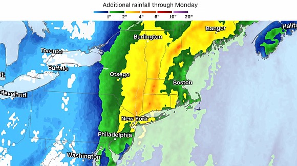
Powerful storm in Northeast threatens miserable morning commutes and widespread urban flooding
CNN/Stylemagazine.com Newswire | 12/18/2023, 7:34 a.m.

Originally Published: 18 DEC 23 01:36 ET
Updated: 18 DEC 23 08:11 ET
By Elizabeth Wolfe and Robert Shackelford, CNN
(CNN) — More than a quarter million customers lost power Monday morning as an intense storm pounded the East Coast with flooding rainfall and strong winds.
Heavy rain and widespread wind gusts of 40 to 50 mph combined to knock out power for over 300,000 customers from Virginia to New England. Those power outages are likely to rise throughout the morning as strong winds continue.
Flood alerts now stretch from Maryland to Maine, with parts several states under warnings for dangerous flash flooding.
Get up to speed:
Happening now: Heavy rain is triggering flash flooding issues from Pennsylvania and New Jersey into New York and Southern New England while widespread wind gusts of 40 to 50 mph stretch from New York City to Maine.
Wind: Will continue to be strong across areas near the coast from New York through Southern New England into Monday afternoon. Breezy conditions will persist in these areas Monday afternoon, but the strongest winds will shift into Maine by Monday afternoon and continue into Monday night.
Heavy rain: The heaviest rain will wind down across New Jersey, Pennsylvania and New York by Monday afternoon but will continue for much of the day across New England.
Coastal flooding: Coastal flood alerts stretch from the mid-Atlantic through the Northeast. Powerful winds are driving water ashore and significant coastal flooding is possible in some areas.
Drivers from Raleigh to New York City could be in for difficult Monday morning commutes as an intense storm system moves up the East Coast, bringing miserable downpours and gusty winds.
Traffic along swaths of the coast’s busy I-95 corridor has been at risk of delays from wind and rain throughout the weekend and into Monday as the storm has advanced from the Southeast and up the coast.
Cities including Philadelphia, Washington, DC, and Virginia Beach could see streets flooding as heavy rains move in. About 58 million people are under flood watches from North Carolina to Maine Monday morning.
New Yorkers could find themselves ankles-deep in floodwaters in some low-lying areas, with around 1 foot of inundation expected.
Minor to moderate urban flooding could inundate parts of New York, New Jersey and Connecticut, particularly in areas with poor drainage, the National Weather Service NWS in New York City said. The risk is especially high for low-lying housing such as first floors, basements and underground residences, it said.
Significant coastal flooding is also possible in Southern New England, where waterways in some parts of Rhode Island may rise to a level not seen in more than 30 years.
More than 15 million people from the Carolinas to Maine were under high wind warnings on Monday morning. Around 45 million people from eastern Georgia to the Northeast were also under high wind alerts late Sunday. The National Weather Service warned strong gusts may make travel particularly difficult in parts of southern Connecticut, southeastern New York and Boston.
These strong gusts may down trees and power lines, as well as damage or blow away outdoor holiday decorations in parts of the region, officials have warned.
The storm wreaked havoc over the weekend in the Southeast and Mid-Atlantic, triggering dangerous flooding in eastern South Carolina and prompting a tornado watch in North Carolina that encompassed more than 1 million people at its peak.
More than 32,000 homes and businesses in Virginia and the Carolinas were still without power late Sunday night, according to the tracker PowerOutage.us.
Air travel is already being disrupted at John F. Kennedy International Airport in New York, where high winds are causing delays of nearly 3 hours on average for flights headed to the airport, according to the Federal Aviation Administration.
The storm system will start to push away from the Northeast later Monday evening, but its effects will likely linger, the weather service said.
“Even though the big storm will begin to depart the Northeast Monday evening, the huge circulation of the storm will overspread the entire eastern U.S. with very blustery conditions,” the weather service said.
Southeast sees damaging flooding, tornado watch
The storm began trekking up the coast on Saturday, sweeping through much of Florida and then skirting the Southeastern coast on Sunday, battering coastal communities with powerful winds and at times record-breaking rainfall.
More than 1 million people in eastern North Carolina were under a tornado watch through Sunday night as the weather service warned wind gusts of up to 65 mph were possible. By 2 a.m. Monday, the watch had narrowed to around 100,000 people.
A flash flood emergency was also issued in South Carolina’s eastern Georgetown County, just south of Myrtle Beach, where water rescues were underway Sunday, the National Weather Service said. The weather service in the region said it has also received reports of snapped power poles, trees fallen on homes and damaged buildings in the area.
About 40 miles south of Myrtle Beach, nearly a foot of rain was recorded in Georgetown, according to the weather service.
The state also saw several record rainfall totals, including 3.86 inches in downtown Charleston, where the last record of 1.18 inches was set in 1923.
CNN’s Nouran Salahieh contributed to this report.


