At least 21 dead from barrage of winter storms and cold – and there’s more on the way
CNN/Stylemagazine.com Newswire | 1/17/2024, 12:35 p.m.

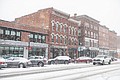
Snow falls on parked cars in Concord, New Hampshire, on January 16.
Mandatory Credit: Will Lanzoni/CNN
By Elizabeth Wolfe, Robert Shackelford and Mary Gilbert, CNN
(CNN) — An unrelenting series of winter storms and an outbreak of cold air have killed several people across a half-dozen states since Friday. Now, another round of extreme cold and snow will march across the central and eastern US, setting up more hazardous travel and a brutally-cold weekend. Here’s the latest:
• More than a dozen storm-related deaths: At least 21 deaths have been reported across Tennessee, Mississippi, Arkansas, Kansas, Oregon and New York since January 12. In Tennessee, where seven fatalities have been reported, a box truck driver was killed Monday evening when he lost control of the vehicle on a snowy Knoxville highway and careened into a tractor-trailer, police said.
• Another round of snow and cold coming: More accumulating snow is likely from the Midwest to the East on Friday. Light totals could once again blanket Washington, DC, and New York City soon after their nearly-two year wait for an inch of snow ended early this week. Read on for a more detailed forecast.
• Ice knocks out power, creates treacherous travel in Northwest: Freezing rain and wind pelting the Pacific Northwest knocked out power to more than 85,000 homes and businesses in Oregon Wednesday morning amid frigid temperatures. Icy roadways and downed trees and power lines created dangerous travel conditions that triggered road closures Tuesday night and Wednesday. A nearly 50 mile-stretch of I-84 from west of Portland to the eastern side of the Oregon Cascades was shut down Tuesday night and early Wednesday due to the ice threat, according to the state’s department of transportation.
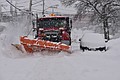
• Buffalo, New York, drivers face snowy conditions: Lake-effect snow warnings are in effect in Buffalo until Thursday night. The surrounding area could see 1 to 3 feet of localized snowfall and wind gusts up to 40 mph. More than 30 inches of snow had fallen south of Buffalo in Lackawanna, New York, as of Wednesday morning. “Travel could be very difficult to impossible. The hazardous conditions could impact the morning or evening commutes,” the weather service warned.
Harsh cold and snow to return
Relief the cold will be short-lived with another push of bone-chilling air set to arrive across the north-central US late Thursday. The abnormal cold will rush across much of the central and eastern US by Friday afternoon and remain in place for most of the weekend.
High temperatures will struggle to reach the freezing mark in Oklahoma City, Nashville, Philadelphia and New York City on Friday. Chicago won’t be able to break out of the teens and Minneapolis will be stuck in the single digits Friday as the harsh cold settles into place.
Wind chills across the central US will plunge back to dangerous levels by Friday, increasing the risk for frostbite and hypothermia.
Another round of snow will overspread portions of the Midwest and East on Friday as two pieces of atmospheric energy – one of which can be traced back to the Northwest storm – collide. Snow will begin as early as Thursday night in Chicago, and by Friday morning, accumulating snow will stretch into the interior Northeast and central Appalachians.
Cities in the mid-Atlantic and Northeast that just ended record-long snow droughts from an early week storm, including Washington, DC, New York and Philadelphia, will once again have the chance for a light-to-moderate snow.
Around 1 to 3 inches of snow are likely from the Midwest to the East, but some parts of the Appalachians may see totals closer to half a foot by the time snow ends Friday night.
Despite low snowfall amounts, the combination of snow and breezy winds could lead to tricky travel. Additional cancellations and delays are also possible, especially after schools and government offices were shuttered by the similarly impactful early-week storm.
Double whammy of ice and snow in Northwest
Back-to-back storms are delivering a deadly “1-2 punch” to the Northwest with freezing rain and ice in Oregon and Washington and heavy snow through the region’s interior through the end of the week, the weather service said.
At least seven people died in the Portland, Oregon, area since Friday from severe winter weather. Four hypothermia deaths are being investigated in Multnomah County, which includes the city of Portland, county officials told CNN.
More than 3 million people in the region were under ice storm warnings early Wednesday, including hard-hit Portland, after a new storm moved onshore Tuesday night.
Ice and wind combined to bring down trees across the Portland area with deadly effect. A tree came crashing down on an elderly man who was asleep on the second floor of his home, killing him, in Lake Oswego, Oregon, fire marshal Gert Zoutendijk told CNN.
“I don’t have enough words to describe what that looked like,” Lake Oswego Police Chief George Burke said during an emergency city council meeting Tuesday.
The highest ice amounts from the storm will be confined to elevated terrain. Up to an inch of ice could form in the South Washington Cascades and the surrounding foothills. Snowfall up to 7 inches and winds gusting up to 40 mph are also expected.
Winter storm warnings also extend over the Cascades and northern Rockies. Up to 3 feet of snow could fall over the Cascades through Thursday afternoon and up to 2 feet is possible in higher elevation areas in the northern parts of Washington, Idaho and Montana by late Thursday morning.
CNN’s Nouran Salahieh, Joe Sutton, Andy Rose, Sarah Dewberry, Raja Razek and Jennifer Henderson contributed to this report.
Also of interest
-
 Northwest faces freezing rain/heavy snow - Arctic blast loosens grip on eastern US
-
 More brutal winter weather is on way after deadly storms and cold
-
 More snow hitting Great Lakes and Northeast, closing schools - hampering travel
-
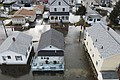 Vicious storm triggers historic coastal flooding - Arctic chill chaser battered US
-
 Vicious storm triggers historic coastal flooding as Arctic chill tees up the South’s first snow