
Tropical Storm Harold makes landfall in Texas, marking the first US landfall of the Atlantic hurricane season
CNN/Stylemagazine.com Newswire | 8/22/2023, 11:38 a.m.

Tropical Storm Harold is expected to dump 3 to 5 inches of rain -- and up to 7 inches in some areas -- across South Texas.
Mandatory Credit: CNN Weather
Originally Published: 22 AUG 23 00:27 ET
Updated: 22 AUG 23 11:20 ET
By Nouran Salahieh and Mary Gilbert, CNN
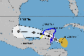
(CNN) — Tropical Storm Harold made landfall on the South Texas coast late Tuesday morning, becoming the first storm in the US to do so in the 2023 Atlantic hurricane season.
Harold came ashore just before 10 a.m. CT (11 a.m. ET) on Padre Island, Texas, with sustained winds of 50 mph and higher gusts, according to the National Hurricane Center. Heavy rain and strong winds will continue to slam portions of South Texas and Mexico and areas farther inland as Harold tracks westward Tuesday afternoon and evening.
Rain will increase in intensity and tropical-storm-force winds will become more widespread across South Texas through Tuesday afternoon.
Tropical storm warnings have been issued from the mouth of the Rio Grande to Port O’ Connor, Texas, with tropical storm watches in effect from Port O’Connor to Sargent, Texas. More than 1 million people are under tropical storm warnings in Texas.
Harold will be able to dump 3 to 5 inches of rain across South Texas on Tuesday and Wednesday with locally higher amounts closer to 7 inches. Across Mexico, 4 to 6 inches of rain are expected.
Tropical-storm-force winds will occur in and around where Harold made landfall with sustained winds of 40 to 50 mph and gusts up to 65 mph likely. As the storm moves inland Tuesday afternoon, wind speeds may ease up slightly but locally-damaging gusts of 30-40 mph will still be possible.
A storm surge of 1 to 3 feet could briefly flood low-lying coastal areas along the mouth of the Rio Grande River to Sargent, Baffin Bay, Corpus Christi and Matagorda Bay. Life-threatening surf and rip currents conditions will last across the southern Texas coast through Tuesday, and it’s possible the state may also see a few tornadoes develop.
The storm threat is moving into southern Texas as the region continues to battle one of its hottest, driest summers on record.
While this tropical system’s rains could help quench parts of the drought-stricken state, some of the worst drought conditions – areas of extreme and exceptional drought in Central Texas – might miss out on much of the rain.
Texans brace for tropical impacts
Texas Gov. Greg Abbott deployed the Texas National Guard, swift water rescue boat squads, among other emergency resources ahead of the storm’s arrival. “Texas stands ready to deploy all available resources to South Texas as tropical storm conditions impact the region this week,” he said in a statement.
“I encourage Texans to remain weather-aware and heed the guidance of state and local officials and emergency management personnel as they work together to keep communities safe,” the governor added.
South Beach and North Beach were closed for driving and camping Monday in anticipation of the storm’s arrival, Padre Island National Seashore officials said. The national seashore is located along a barrier island south of Corpus Christi.
Corpus Christi officials told residents who must be outside during the incoming storm to drive slower than usual, turn on their headlights and be aware of possible flooding in low-lying areas.
Crews across the Corpus Christi area could be seen working Monday to prep critical canals and drainage infrastructure for the heavy rainfall.
About 40 miles northeast, the city of Port Aransas declared a local state disaster on Monday ahead of impacts from the storm.
The city is “under the threat of imminent disaster, injury, or loss of life or property, resulting from a Tropical Storm, which will impact the coastal beaches of the City of Port Aransas Nueces County, Texas with flooding or severe damage,” the proclamation said.
Naval Air Station Kingsville ordered those in the RV Park on the installation to evacuate, while voluntary evacuations were called in Riviera, Baffin Bay and Loyola Beach, authorities said.
Meanwhile, AEP Texas, which delivers power to South Texas, said it is lining up crews, equipment and other resources in anticipation of possible power outages.
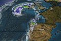
Franklin packing potentially life-threatening flooding
Tropical Storm Franklin is set to slam Hispaniola by Wednesday with life-threatening flooding and mudslides. The storm will also bring heavy rainfall to Puerto Rico.
Franklin had sustained winds of 50 mph as of Tuesday morning, and was located over the Caribbean Sea about 260 miles south of Santo Domingo, Dominican Republic. It is expected to make a hard turn to the north later Tuesday and make landfall in Hispaniola Wednesday.
Franklin will unload very heavy rain across Hispaniola Tuesday through Wednesday and raise the threat of flash flooding and mudslides. Isolated rainfall amounts up to 15 inches possible. Up to 6 inches of heavy rain could fall in Puerto Rico through Thursday, but the island will escape the worst of Franklin.
The Atlantic hurricane season is ramping up. Three tropical systems formed in 24 hours Saturday into Sunday. Harold now marks the fourth in four days.
Also of interest
-
 Tropical Storm Philippe will deliver another wet, miserable weekend to the Northeast
-
 Tropical Storm Franklin Makes Landfall in Mexico
-
 Flash flood risk grows for coastal Texas and Louisiana as Tropical Storm Nicholas takes aim
-
 Ireland On Lockdown as Former Hurricane Ophelia Makes Landfall
-
 Massive Hurricane Lee a growing threat to New England, Canada