Tropical Storm Franklin Makes Landfall in Mexico
CNN/Stylemagazine.com Newswire | 8/8/2017, 10:30 a.m.
By Keith Allen and Michael Guy, CNN
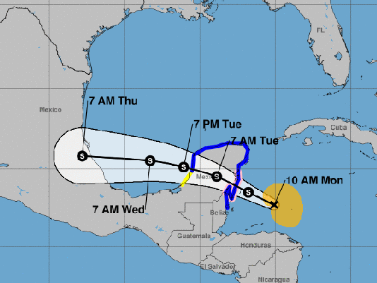
(CNN) -- Tropical Storm Franklin made landfall on the eastern coast of Mexico's Yucatan Peninsula late Monday, according to the National Hurricane Center. Franklin moved inland with maximum sustained winds of about 60 mph.
A hurricane watch is in effect for the Mexican coast, ranging from Puerto de Veracruz to Rio Panuco. Tropical storm warnings are in place for a larger portion of the region, encompassing the coast of Mexico from Chetumal to Sabancuy, and from Belize City in Belize northward to the Mexican border.
The storm continues to batter Belize and the Yucatan Peninsula with heavy rain and strong winds, and flash flooding is still a major concern. Tropical storm-force winds extend outward up to 140 miles from the storm's center.
Track the storm
Expected rainfall amounts vary between 3 and 6 inches, with some areas across the Yucatan Peninsula and Belize may receive as much as 12 inches of rain through Wednesday, according to the center's advisory.
The storm will continue to move toward the west-northwest and should move out into the Bay of Campeche over the next 24 hours, according to the National Hurricane Center. On the current track, Franklin will move across the Yucatan Peninsula Tuesday and will gather strength as it moves over the Bay of Campeche.
Further strengthening is expected when it gets into the warm waters as it heads toward the Mexican coastline for a second landfall sometime early Thursday morning as a Category 1 hurricane between Tampico and Veracruz.
Belize's National Meteorological Service issued a small craft warning Monday night, and advised vessels north of Belize City to seek safe harbor. They expect very rough seas with 8- to 10-foot waves overnight into Tuesday.
The National Weather Center advises that water levels could rise as much as two feet above normal tide levels along the eastern Yucatan Peninsula early Tuesday morning.


